Norfolk is a rural suburban town on the periphery of metropolitan Boston, located on an upper valley of the Charles River. There were a half dozen small farms in the town after 1669, the result of a determined effort to populate the Colonial frontier. This was seen as a difficult task despite the good agricultural lands, fresh water fishing and fish runs because the settlement was so remote.
It was abandoned during the King Philip’s war, and when Norfolk was re-established settlers relied on agriculture and cattle grazing with some considerable lumbering and planting of orchards. After 1812, three cotton manufacturing companies were established at Stony Brook, and later in the 19th century George Campbell’s paper mill was opened at Highland Lake making heavy wrapping and building papers. The town saw a rapid increase in population after 1925 when a hospital and a state prison were built in Norfolk. Major residential development took place before 1940 in the Pondville and Clark Streets section of town with scattered new housing along Seekonk and Main Streets, and suburban residential building has continued since.
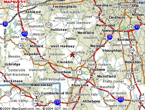
It is located in eastern Massachusetts, bordered by Millis and Medfield on the north, Walpole on the east, Foxborough and Wrentham on the south, and Franklin and Medway on the west. Norfolk is 20 miles southeast of Boston; about 28 miles north of Providence, Rhode island; and about 205 miles from New York City.


